Case Study
2°C LEAF
Purpose-Driven Engineering
Building the iOS Platform for a Citizen Science Climate Sensor Network.
2°C LEAF
Tech Partnership
Purpose-Driven Engineering
6 Months
- iOS app for BLE-based climate data collection
- Background BLE + GPS with battery optimisation
- Privacy-first anonymized data system
- Simple, user-friendly outdoor experience

KeyOutcomes
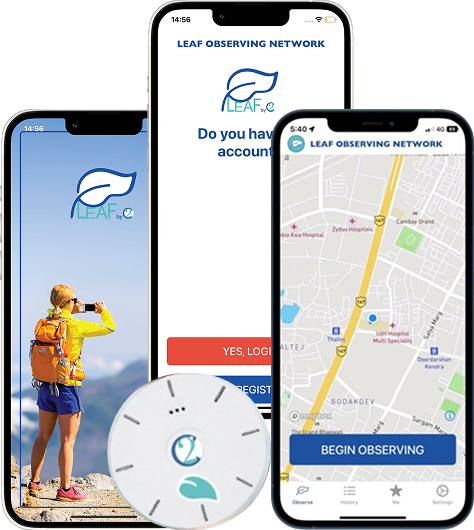
Built a production iOS app (5.0 App Store rating) that pairs with the LEAF climate sensor via BLE to collect georeferenced environmental data for scientific research
Engineered background BLE + GPS operation that maintains continuous data collection during outdoor activities without excessive battery drain on the user’s iPhone
Delivered a privacy-first architecture where no personal data is collected by the developer — only anonymised, georeferenced climate observations reach the scientific community
The Challenge
Before partnering with Iottive, 2DegreesC was facing several critical obstacles:
Designing for Outdoor Extremes
The LEAF sensor is carried by hikers, runners, climbers, and swimmers through rain, snow, desert heat, and high altitude. The iOS app had to maintain stable BLE connections across temperature extremes (- 20°C to 50°C ambient), handle sensor data anomalies caused by rapid environmental changes, and recover gracefully when conditions push hardware to its limits.
Background Operation Without Draining the Phone
Citizen scientists carry the LEAF sensor during hours-long outdoor activities. The app must simultaneously maintain a BLE connection to the sensor and run background GPS for georeferencing — two of the most power-intensive operations on iOS. If the app drains the phone’s battery during a backcountry hike, it becomes a liability rather than a tool.
Scientific Data Validation
Data destined for climate researchers must meet scientific standards. The app needed to validate readings against plausible ranges, flag sensor anomalies, timestamp observations with GPS-synchronized precision, and ensure georeferencing accuracy sufficient for climate modeling. Garbage data would undermine the entire network’s credibility.
Making Technology Accessible to Outdoor Enthusiasts
2DegreesC’s users are outdoor enthusiasts first, technologists second. The app had to make BLE pairing, sensor calibration, data collection, and cloud upload feel effortless ideally invisible — so users focus on their hike, not their sensor. If setup takes more than a minute, adoption drops.
Our Solution
Iottive delivered a purpose-built iOS application under a full-cycle product development model.

BLE Sensor Integration
We implemented a robust BLE communication layer that reads environmental data (temperature, humidity, barometric pressure, and additional parameters) from the LEAF sensor’s custom GATT service. The connection protocol handles intermittent signal loss during vigorous outdoor activity and automatically resumes data collection when the link restores.

Design Thinking Approach
We collaborated with 2DegreesC’s science team and early beta testers trail runners, mountaineers, and field researchers — to understand how the app fits into an active outdoor routine. The design principle was “start and forget”: pair the sensor once, then the app does everything in the background. The interface surfaces data only when the user actively wants to see it.

Project Planning & Execution
Development followed a validation-first approach: BLE data accuracy was verified against calibrated reference instruments before any UX work began. We conducted field tests in varied environments — urban heat islands, mountain trails, coastal regions — to validate performance under real conditions. The 501(c)(3)’s limited budget required disciplined scope management.

Functionalities Delivered
The production app includes: one-tap BLE sensor pairing, continuous background data collection with GPS georeferencing, on-device data validation and anomaly flagging, cloud upload of anonymised observations to the 2DegreesC scientific platform, real-time environmental readings display, and session history for users to review their contributions.
Implementation Highlights

Sensor Data Acquisition
Built a multi-parameter BLE data pipeline that reads environmental variables at configurable intervals (default: 30 seconds). Each reading is timestamped using the phone’s NTP synchronized clock and tagged with GPS coordinates, creating a continuous spatial-temporal record of conditions along the user’s path.

Edge & Connectivity
Implemented iOS background modes for BLE and location services with adaptive duty cycling. In areas with stable conditions, the app reduces GPS polling frequency to conserve power. When rapid environmental changes are detected (e.g., altitude gain), it increases sampling density automatically.

Power Management
Developed a tiered power strategy: full-resolution sampling when the phone is above 40% battery, reduced sampling below 40%, and graceful shutdown with data preservation below 15%. Field testing confirmed 6+ hours of continuous background operation on an iPhone 14, sufficient for a full-day hike.

Data Validation & Quality Control
Each sensor reading passes through on-device validation: range checks against physically plausible values, rate-of-change limits to catch sensor spikes, and cross-validation between parameters (e.g., dew point consistency with temperature and humidity). Flagged readings are marked but still transmitted, allowing scientists to apply their own filters.

Dashboard & UX
The app’s primary screen shows a simple status indicator: sensor connected, data collecting, GPS active. Users who want detail can expand to see live readings and a map of their data trail. The visual language uses earth tones and nature-inspired typography — reinforcing that this is an environmental tool, not a tech gadget.

Privacy & Data Handling
No personal information is collected, stored, or transmitted. GPS coordinates are associated only with environmental readings, not user identities. Data uploads use anonymised session IDs. The architecture was designed to meet the nonprofit’s commitment that “no data is collected by the developer” — a claim verified by App Store privacy review.
Results & Impact
- Achieved a 5.0 App Store rating, reflecting strong user satisfaction with the app’s reliability and simplicity
- Enabled continuous background data collection for 6+ hours on modern iPhones without user intervention
- Delivered scientifically valid georeferenced observations used by climate researchers to fill gaps in monitoring networks
- Maintained zero privacy incidents—no personal data collected, aligned with 2DegreesC’s nonprofit mission
- Supported 2DegreesC’s fundraising efforts by demonstrating a production-quality mobile platform to donors and institutional partners
“Our mission depends on making science effortless for everyday people. Iottive built an app that disappears into the background — literally. Our users go for a hike, and when they get home, they’ve contributed real climate data without ever thinking about the technology. That’s exactly what citizen science should feel like.”
—Arif Quronfleh , 2DegreesC
Lessons & Best Practices
Validate Data Quality Before Building the UX
For any application feeding scientific databases, data integrity must be proven first. We spent the first sprint establishing that BLE-acquired readings matched reference instruments before writing a single UI component.
Background Operation Requires Obsessive Power Testing
iOS background modes are powerful but punishing. Every percentage point of battery drain matters when your app runs for 6+ hours. We maintained a power regression test suite and flagged any code change that increased drain by more than 2%.
Nonprofit Budgets Demand Ruthless Prioritization
2DegreesC operates on donations. We prioritized features by scientific impact per development hour, deferring cosmetic refinements in favor of data reliability and sensor compatibility.
Let the Environment Inform the Design
An app used on mountain trails in bright sunlight needs different contrast ratios than one used indoors. We field-tested readability at altitude, in rain, and while running — and adjusted the UI accordingly.

Technology
Comprehensive IoT Technology Stack
From devices and connectivity to cloud, apps, and security — we leverage a full-stack IoT ecosystem to build scalable, secure, and future-ready solutions.

iOS ( SwiftUI)
BLE

Why Iottive’s the Right Partner
- Specialized experience in BLE sensor integration for environmental and scientific applications — not just consumer gadgets
- Proven track record of building iOS background-mode applications that balance continuous data collection with responsible power consumption
- Commitment to purpose-driven engineering: we treated 2DegreesC’s climate mission as a design constraint, not just a marketing narrative
Next Steps for 2°C LEAF

Develop an Android companion app to expand the citizen scientist base beyond iOS users
Integrate support for the Wavelet ocean sensor, extending the platform from terrestrial to marine environments
Build a public-facing data dashboard where contributors can see aggregate climate insights from the global LEAF network
Explore partnerships with national weather services and university research programs for institutional deployment of the LEAF sensor array