One late afternoon at a busy logistics yard, a heavy load hovered near stacked pallets when a sudden gust pushed it toward a crane. A system of cameras and sensors saw the risk, rerouted the path, and guided the vehicle back to its dock. The team exhaled. The package and people were safe.
That moment shows how modern systems combine perception, path planning, and avoidance into a single, reliable capability for cargo operations. Organizations in logistics and industry now expect features that cut risk, automate workflows, and boost flight reliability without constant manual control.

Iottive builds the IoT and mobile back ends, BLE accessories, and cloud integrations that make these solutions usable in production. Expect multi-directional vision, thermal feeds, and intelligent rerouting to extend surveillance and protect property day and night.
Practical safety gains are available now. With the right platform and partners, fleets can scale reliable operations and reduce loss events across yards and corridors. Contact Iottive at www.iottive.com or sales@iottive.com to learn more.
Key Takeaways
- Perception plus path planning creates real-world avoidance and reliable flight operations.
- Industry buyers want integrated solutions — hardware, docks, software, and cloud.
- Multi-sensor vision and thermal views expand surveillance windows for inspections.
- Predictive decision-making and redundancy matter more than raw speed or payload.
- Iottive provides BLE, mobile, and cloud building blocks to deploy these systems at scale.
Why collision avoidance is reshaping cargo drone safety right now
Automated avoidance systems are now a core requirement for large-scale aerial operations. Busy yards, cranes, tall structures, and shifting weather raise the risk profile for routine flights. Modern sensing and route planning cut that risk while improving repeatability.

Pairing drones with docks or nests extends uptime. Dock systems like DJI Dock 2 automate launch, landing, and charge cycles. That reduces downtime from limited flight time and supports near-continuous missions in harsh conditions.
| Platform | Coverage | Uptime | Best use |
|---|---|---|---|
| Tethered | Fixed-area | Very high (continuous power) | Persistent monitoring and perimeter watch |
| Free-flight | Broad routes | Moderate (battery cycles) | Route-based patrols and deliveries |
| Docked (dock/nest) | Hybrid | High (automated charging) | 24/7 aerial surveillance and scheduled sorties |
- Automated avoidance lowers incident rates and can reduce insurance exposure for fleets.
- Smarter flight planning and return-to-base reduce pilot workload and improve compliance readiness in U.S. operations.
- Reliable operations depend on strong cloud/mobile integration and real-time data and alerting pipelines.
Enterprises should evaluate features alongside operational models. Consider docking, fleet rotation, and maintenance schedules when selecting systems. Iottive supports regulated U.S. rollouts with cloud/mobile integration and BLE peripherals to speed deployment and ensure consistent performance.
What AI collision avoidance means for cargo drones
Perception, prediction, and on-board decision loops turn raw sensor data into safe route updates during missions. This cycle is the backbone of reliable avoidance: sense, interpret, decide, and act. Iottive builds IoT/AIoT platforms that stitch sensor fusion, edge inference, BLE, cloud, and mobile apps together to make those steps operational.

Sensing, perception, and real-time decision-making
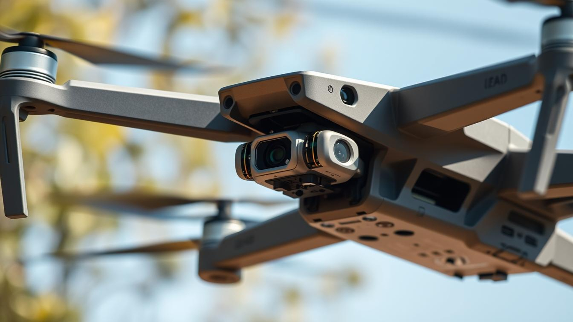
Sense: Cameras, LiDAR, and depth sensors feed continuous frames to onboard software. This supports object detection and fine-grained tracking near cranes, masts, and moving vehicles.
Perceive: Algorithms classify objects and predict motion. Sensor fusion improves robustness in low light and cluttered yards.
Decide: Confidence thresholds and battery margins trigger route updates or return-to-base actions to finish a mission safely.
From obstacle detection to rerouting and return-to-base
Core features include obstacle detection, intelligent rerouting, hover-and-hold, and safe braking behaviors. On-edge inference handles immediate avoidance while cloud updates refine models over time.
“Validation through structured tests and logged decisions is essential for auditability and operational trust.”
- Onboard algorithms predict object motion and adjust flight paths in real time.
- Fine-grained tracking lowers pilot workload while keeping human oversight for high-risk cases.
- Prioritizing avoidance over shortest routes ensures compliance and public confidence.
Product roundup: Leading AI collision avoidance platforms for airborne logistics
Below we compare the top models that combine robust sensing, extended flight times, and dock compatibility for site patrols.

Skydio X10
Strengths: 360-degree avoidance, multi-sensor camera suite (64 MP narrow, 48 MP tele, 50 MP wide) plus 640×512 radiometric thermal. Up to 40 minutes of flight time and IP55 durability make it ideal for yard and route surveillance. Dock compatible for reduced downtime.
DJI Matrice 3D/30T with Dock 2
Strengths: Up to 50-minute flights, IP54 aircraft rating and Dock 2 at IP55. Designed for long missions and automated launch/land/charge cycles. Operates in -25°C to 45°C and supports persistent site coverage with a 5-hour backup battery.
Percepto Air Max
Strengths: Integrated base station, built-in AI analytics, and autonomous charging for continuous perimeter patrols and industrial inspections. Minimal human oversight needed for scheduled runs and reporting.
Sunflower Labs Beehive
Strengths: Rapid deployment (~5 seconds), 1080p Sony IMX385 camera, 15-minute flight with reserves, and a weatherproof Beehive base that recharges in ~22 minutes. Suited for quick-response perimeter awareness.
Autel EVO II Enterprise
Strengths: 20 MP 1″ CMOS, 6K capture, 360° obstacle sensing with 19 sensor groups, Dynamic Track 2.1, and roughly 42 minutes of flight time for efficient patrols and mapping tasks.
Comparing models: Consider obstacle avoidance, flight time, camera payloads, and dock compatibility when choosing a fleet. Extended flight times and automated docking cut downtime across multi-shift operations. Camera versatility—zoom, wide, and thermal—lets teams handle day/night conditions and limited visibility.
Select models to match site size, regulatory limits, and the desired autonomy level. Iottive can integrate these platforms into a unified ops dashboard with BLE accessories, alerts, and reporting to streamline surveillance and delivery workflows.
The tech stack behind collision avoidance: sensors, cameras, and onboard AI
Layered sensors and on-board models convert raw readings into actionable flight updates in seconds.

LiDAR, radar, and multi-directional vision systems
LiDAR builds precise 3D maps for short-range mapping and terrain clearance.
Radar provides robust detection in dust, rain, or glare where optical feeds struggle.
Multi-directional vision covers blind spots and complements range sensors to improve overall detection.
Thermal and low-light cameras for 24/7 surveillance
Thermal imaging reveals heat signatures at night and through obscurants. Low-light camera modes keep imagery clear after dusk.
Edge ML for object recognition and predictive paths
On-edge algorithms classify objects, detect anomalies, and predict motion. These models reduce latency between detection and course changes.
Connectivity: LTE/5G, cloud offload, and smart alerts
Reliable LTE/5G links stream live data and push smart alerts to operations centers. Cloud offload centralizes recordings for audits and model training.
| Sensor | Role | Strength |
|---|---|---|
| LiDAR | 3D mapping | High precision range |
| Radar | Obstacle detection | All-weather reliability |
| Vision | Classification & tracking | High resolution context |
“Calibration, health monitoring, and tested integrations are key to long-term operational trust.”
Iottive ties sensor fusion, edge inference, BLE accessories, and cloud/mobile dashboards together to operationalize alerts and analytics across industries. Select modules that interoperate with docks like the DJI Dock 2 to automate charging and data handoffs.
Autonomous flight modes that enhance cargo mission safety
Automated mission templates streamline routine inspections and make complex patrols easier to run across shifts. These templates encode standard operating procedures so teams repeat the same safe route every time.
Intelligent flight modes and detect-and-avoid behaviors
Intelligent flight modes and detect-and-avoid behaviors
Workflows include auto-takeoff/land, waypoint missions, and adaptive path replanning. These modes let operators launch reliable sorties with minimal input.
Detect-and-avoid routines change speed, heading, or altitude when a hazard appears. Onboard logic uses sensor checks and triggers safe fallback actions such as hover or return-to-base.

Geofencing, GPS/RTK precision, and obstacle-aware path planning
Geofencing and GPS/RTK give centimeter-level positioning for strict route adherence and no-fly zone compliance. That precision reduces drift on long corridors and tight perimeters.
Obstacle-aware planning fuses sensor inputs to reroute around cranes, vehicles, or temporary structures. Clear flight paths and automated return-to-base reduce operator fatigue and errors.
Tethered versus free-flight strategies for continuous coverage
Tethered systems offer continuous power but limited range. Free-flying units cover broader areas but need redeployment or docks for persistence.
Choose tethered, docked, or mixed strategies based on site geometry and mission goals. Standardized mission templates help repeat safe routes across shifts and locations.
“Onboard checks for sensor state and GNSS integrity should trigger safe fallback behaviors when needed.”
| Mode | Primary benefit | Best use |
|---|---|---|
| Waypoint mission | Repeatable routes | Perimeter sweeps, corridor inspections |
| Adaptive replanning | Dynamic reroute | Temporary obstacles, moving vehicles |
| Tethered operation | Continuous power | Persistent monitoring of fixed sites |
| Docked sorties | Automated redeploy | 24/7 coverage with minimal staff |
Iottive exposes mission planning, geofencing, and alerting in mobile and cloud controls. BLE accessories extend field operability and let teams encode SOPs into app-driven modes for consistent results.
Deploying at scale: docks, nests, and compliance for U.S. operations
Scaling site-wide operations requires hardened infrastructure, clear procedures, and audited comms. Docks and nests let teams run scheduled patrols and react to alerts with minimal staff.
Drone-in-a-box workflows for 24/7 patrol and automated charging
Automated shelters schedule sorties, manage recharge cycles, and trigger missions from alerts. Multiple docks rotate aircraft to preserve battery health and extend overall uptime.
DJI Dock 2 example: IP55 ingress, ~34 kg, a 5-hour backup battery, and -25°C to 45°C operation enable reliable all-weather surveillance.
Operating under Part 107 and preparing for BVLOS safety cases
Part 107 rules affect visual line-of-sight, daylight ops, and waiver needs. Prepare evidence: detect-and-avoid tests, robust command links, and procedural mitigations for BVLOS.
“Pilot programs that log telemetry and incident reports make regulatory approvals faster.”
| Capability | Benefit | Best use |
|---|---|---|
| Multiple docks | Continuous coverage | Perimeter and corridor surveillance |
| Backup power | All-weather uptime | 24/7 aerial surveillance |
| Role-based access | Audit-ready reports | Compliance and incident handling |
Iottive integrates dock telemetry, maintenance alerts, and compliance reporting into one dashboard. Secure telemetry, video handling, and site layout checks reduce RF and obstacle risks before scale.
High-impact applications across industries
Modern aerial platforms deliver real-time footage and sensor feeds that change how teams monitor large sites.
Iottive supports multiple industries by connecting sensors, mobile apps, and cloud tools so teams get actionable data fast.
Logistics, delivery corridors, and warehouse perimeter security
Security drones patrol yards and gates to detect unauthorized access and flag events to ops centers.
Scheduled routes cover warehouse perimeters and indoor aisles to cut shrink and speed response.
Industrial inspections and critical infrastructure monitoring
Thermal detection and zoom cameras make tank farms, substations, and pipelines easier to inspect.
Geofenced patrols and automated escalation rules help teams act on anomalies before issues grow.
Search and rescue with thermal detection and real-time data
Rapid launch and thermal tracking reduce time to locate missing persons in difficult terrain.
High-quality aerial footage streams to command posts for coordination and evidence capture.
“Real-time feeds and robust tracking turn routine patrols into mission-ready response tools.”
| Use case | Primary benefit | Key capability |
|---|---|---|
| Yard & delivery corridors | Reduced theft and faster incident response | Perimeter patrols, alerts, and vehicle tracking |
| Warehouse aisles | Lower shrink and automated anomaly detection | Scheduled routes, indoor mapping, and camera feeds |
| Industrial sites | Targeted inspections with less downtime | Thermal detection, zoom, and geofenced checks |
| Search & rescue | Faster locate and rescue coordination | Thermal sensors, rapid launch, and live data links |
- Real-time data streams ensure operations centers have evidence and context for decisions.
- Aerial surveillance footage supports incident reconstruction, training, and audits.
- Different industries prioritize detection, cameras, and analytics to match each risk profile.
- Iottive accelerates deployments across Healthcare, Automotive, Smart Home, Consumer Electronics, and Industrial IoT by customizing dashboards and integrations for specific needs.
How Iottive accelerates AIoT collision avoidance for cargo drones
Iottive speeds deployments by turning complex sensor stacks into cohesive, production-ready platforms. The company pairs edge processing, cloud pipelines, and mission apps so teams move from pilot to production faster.
Custom IoT/AIoT platforms: sensor fusion, edge AI, and cloud/mobile integration
Sensor fusion frameworks unify vision, LiDAR, and radar feeds to produce robust, low-latency decisions. On-device inference handles time-critical tasks while the cloud refines models and stores telemetry.
Result: reliable avoidance decisions that respect battery margins and site rules.
BLE-connected accessories and smart device interoperability
BLE beacons, tags, and wearables add localization layers and personnel awareness at the edge. Mobile apps provide mission control, SOP checklists, and role-based workflows for operators.
End-to-end solutions across industries
Iottive builds cloud pipelines that ingest telemetry, video, and events into searchable, audit-ready stores. Integrations work with docks (Skydio, DJI Dock 2, Percepto, Sunflower Labs) and enterprise VMS/PSIM systems for cohesive operations.
- Security-by-design: encryption, RBAC, and compliance reporting.
- Engagements run from discovery to production-scale rollouts across Healthcare, Automotive, Smart Home, Consumer Electronics, and Industrial IoT.
Contact: www.iottive.com | sales@iottive.com — request a tailored roadmap that connects operational capabilities with measurable ROI.
Conclusion
Field-proven platforms and integrated workflows are raising the bar for reliable perimeter and corridor monitoring.
Autonomous avoidance now transforms operational safety and reliability for cargo missions and perimeter patrols. Choosing the right features and flight time profiles yields consistent coverage with fewer manual checks.
Use cases span logistics corridors, critical infrastructure, and search and rescue. Multi-sensor payloads and thermal/zoom cameras improve awareness and overall performance. High-quality aerial footage and recorded telemetry create a defensible record for audits and compliance.
Iottive can help design, build, and deploy end-to-end AI-powered drones and AIoT safety systems tuned to site risk and regulatory pathways. Reach out: www.iottive.com | sales@iottive.com for a scoped plan that maps features to applications and operational goals.
FAQ
What is collision avoidance and why does it matter for cargo drones?
Collision avoidance refers to systems that detect obstacles and steer a vehicle away from them. For cargo aircraft used in logistics, these systems reduce mission risk, protect payloads, and support regulatory approvals for extended operations beyond visual line of sight.
Which platforms lead the market in onboard avoidance capabilities?
Several manufacturers stand out. Skydio X10 offers full 360-degree sensing and autonomous navigation. DJI’s Matrice series with Dock 2 supports long missions and automated ops. Percepto Air Max focuses on autonomous patrolling, while Autel’s EVO II Enterprise provides multi-directional sensing and Dynamic Track functions.
What types of sensors form the core of modern avoidance stacks?
Effective stacks combine LiDAR, radar, and multi-directional vision cameras. Thermal and low-light sensors extend operational windows. Sensor fusion with onboard processing yields accurate object detection and helps craft safe reroute decisions in real time.
How do real-time decision systems work during a mission?
Edge processors run machine learning models to classify obstacles, predict trajectories, and compute escape maneuvers. When a hazard is detected, systems choose actions—hover, reroute, or return-to-base—based on risk thresholds and mission constraints.
Can these systems operate continuously for 24/7 surveillance or delivery?
Yes. Combining thermal cameras, low-light imaging, tethered options, or dock-in-a-box charging enables around-the-clock coverage. Proper hardware resilience and automated charging workflows allow sustained operations without frequent manual intervention.
What connectivity standards support streaming and remote control?
LTE and 5G networks allow high-bandwidth telemetry and video streaming. Secure cloud offload and smart alerts enable operators to monitor fleets, update models, and handle exceptions from remote consoles or mobile apps.
How do intelligent flight modes improve mission safety?
Intelligent modes include terrain following, obstacle-aware path planning, Dynamic Track, and automated return behaviors. Geofencing and GPS/RTK positioning add precision, while detect-and-avoid routines adapt paths when new obstacles appear.
What role do docks, nests, and “drone-in-a-box” systems play for scale?
Docking stations provide automated charging, secure storage, and rapid redeployment. They simplify BVLOS operations, enable scheduled missions, and support compliance by providing logs, telemetry, and maintenance workflows.
How do operators meet Part 107 and BVLOS requirements in the U.S.?
Operators must follow FAA guidance, secure waivers for BVLOS where needed, implement detect-and-avoid measures, and maintain operational records. Demonstrating reliable sensing, fail-safe behaviors, and risk mitigation helps obtain approvals.
Which industries benefit most from advanced avoidance and autonomous modes?
Logistics and last-mile delivery, warehouse and perimeter security, industrial inspections, infrastructure monitoring, and search and rescue all gain from robust sensing, payload handling, and extended flight times enabled by modern systems.
How does sensor fusion improve obstacle detection in cluttered environments?
Fusion combines data from LiDAR, radar, and cameras to reduce false positives and detect small or low-contrast objects. This layered approach increases situational awareness in urban corridors, near structures, or during complex inspections.
Are thermal sensors essential for search and rescue missions?
Thermal imaging greatly enhances detection of people and heat sources, especially in low light or adverse weather. When paired with real-time telemetry, teams can act faster and coordinate ground responders with precise coordinates.
What are typical failure modes and how are they mitigated?
Failures include sensor occlusion, GNSS loss, or communication outages. Systems mitigate these with redundant sensors, inertial navigation backups, return-to-base or safe-hover behaviors, and automated alerts to operators.
How do edge AI and cloud services split workload for collision avoidance?
Time-critical perception and control run on edge hardware to ensure low latency. Cloud services handle fleet analytics, model training, and long-term storage. This balance keeps flight decisions fast while enabling continuous improvement.
What interoperability exists between payloads, BLE accessories, and ground systems?
Modern platforms support BLE peripherals for sensors and payload triggers, APIs for cloud/mobile integration, and standard telemetry links. Interoperability allows third-party sensors, health monitoring, and seamless mission automation.
How do manufacturers ensure extended flight times for logistics missions?
Improvements come from higher-efficiency motors, optimized propellers, battery management systems, and modular payload designs. Docking stations and swappable battery workflows also extend effective mission duration.
What testing is required before deploying automated delivery corridors?
Operators perform site surveys, risk assessments, hardware-in-the-loop testing, and staged flight trials. They validate detect-and-avoid performance, communications reliability, and emergency procedures before live service.
How can companies evaluate vendors for airborne logistics platforms?
Assess sensing breadth, software maturity, integration APIs, dock compatibility, compliance support, and field performance data. Look for proven deployments, open telemetry standards, and post-sale support for model updates.
What privacy and regulatory concerns should operators address?
Operators must follow data protection laws, secure telemetry and video streams, and restrict collection to mission needs. Obtaining local permissions and clearly communicating operations to communities reduces legal and reputational risk.